

THE MOST BEAUTIFUL ROUTE IN THE WORLD IS IN CHILE AND IS CALLED
AUSTRAL HIGHWAY
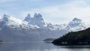
Immerse yourself in the magical journey along the Carretera Austral in Chilean Patagonia, an experience that awakens all your senses and connects you with nature in its purest state. From the imposing snow-capped peaks to the lush forests and crystal-clear rivers, every curve of this route presents you with landscapes that seem straight out of a dream. A journey that leaves an indelible mark on the hearts of those who venture to explore it!
On its routes, you can enjoy evergreen forests and stop for trekking in national parks such as Queulat, the Futaleufú National Reserve, Hornopirén National Park, Pumalín Park, and the Lago Rosselot National Reserve, among others that are difficult to detail.
The Carretera Austral is one of the world's most spectacular scenic routes. A 1,240-kilometer journey that crosses Chilean Patagonia from Puerto Montt to Villa O'Higgins in the southernmost tip of Chile.
SAILING AFTER THE CARRETERA AUSTRAL.
And if all this isn't enough, embark on a unique journey through the Patagonian fjords by ferry between Puerto Yungay and Puerto Natales. This tour is not just a means of transportation, but an unforgettable experience that immerses you in the majesty of southern Chile. On board, you'll contemplate breathtaking landscapes of snow-capped mountains, ancient glaciers, and calm waters that reflect the unspoiled beauty of the region. Traveling by ferry is a comfortable, safe, and sustainable way to discover deep Patagonia, connecting scenic routes and isolated communities while enjoying the serenity of the southern ocean. Join this adventure and discover the magic of the end of the world from a unique perspective!
"And don't forget: once you reach this last bastion, Puerto Natales, your dreams don't end... they're just beginning to take shape. You're about to culminate your odyssey at the gates of the imposing Torres del Paine National Park, the eighth wonder of the world. A sanctuary of stone, wind, and eternity awaits you."
In case your trip starts from Punta Arenas or Puerto Natales and you do it in a rented vehicle, you must ensure that it is "released" meaning that it was not originally purchased under the free trade zone regime, which is a benefit for the inhabitants of this region of Chile, otherwise the vehicle will require the processing of a "customs pass" to travel from Punta Arenas to the north of the country via the Carretera Austral and you must control the exit from the Magallanes region in the town of "CONTAO" (customs control) 16 km from "Caleta Puelche" where you can board to cross to "Caleta la Arena" to continue towards Puerto Montt.
You will be informed of the above at the Rent a Car itself.
ORIGINS OF THE ROAD
The Carretera Austral, officially known as Route CH-7, begins in Puerto Montt and extends to Villa O'Higgins, crossing regions of lakes, fjords, glaciers, ancient forests, and mountains, as well as passing through various picturesque towns and cities. It was built during Augusto Pinochet's military regime in the 1970s to connect isolated areas in the south of the country. Today, it has become one of the most sought-after tourist destinations for those seeking adventure and relaxation.
Natural Wonders: An Outdoor Paradise
- Incomparable Landscapes
From Queulat National Park, with its impressive Hanging Glacier, to the turquoise waters of General Carrera Lake, the Carretera Austral offers natural landscapes with every mile. Travelers can admire ancient glaciers, such as Exploradores, and lose themselves in alerce forests that are over 3,000 years old.
- Adventure without Limits
The route is ideal for lovers of trekking, cycling, kayaking, fly fishing, and rafting on rivers like the Baker and Futaleufú. Many travelers explore the route by bike, challenging their own physical limits while immersing themselves in one of the continent's most pristine landscapes.
- Real Disconnection
With poor cell phone service in many stretches and infrastructure still under development, traveling along the Carretera Austral means a complete disconnect from urban noise. This lack of connectivity becomes a virtue for those seeking peace, reflection, and authentic contact with nature.
- Patagonian Culture and Hospitality
Although the route passes through remote areas, each town has its own charm: Puyuhuapi, Coyhaique, and Puerto Río Tranquilo, among others, offer warm hospitality. The local culture, forged by the harsh climate and geography, is reflected in its resilient, welcoming people, who are proud of their land.
The cuisine is another attraction: spit-roasted lamb, fresh trout, homemade empanadas, and calafate jams are all part of the experience.
A Journey of Transformation
Traveling the Carretera Austral isn't just about exploring a place; it's about experiencing an emotional and spiritual adventure. It's about contemplating the immensity of nature and feeling small, yet part of something much larger. It's about rediscovering simplicity, appreciating silence, and learning to travel slowly.
Recommendations for the Traveler
- Planning: Some areas require ferry or advance reservations. It's essential to check the route and weather conditions.
- Fuel There are long stretches without gas stations. Filling up your tank at every opportunity is key.
- Respect for Nature: Not leaving litter, not lighting fires in unauthorized areas, and protecting ecosystems is everyone's responsibility.
- Equipment: Whether by car, bicycle, or on foot, carrying waterproof clothing, a first-aid kit, maps, and food is essential.
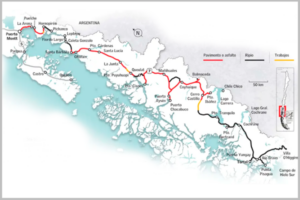
ROUTE SUMMARY
Here's a list of the most notable cities and towns you can visit while traveling the Carretera Austral from north to south:
Northern Austral Highway
Puerto Montt – Official departure point. Large city with an airport.
Puerto Varas – Very close to Puerto Montt. Although it's not directly on the Carretera Austral, many travelers visit it before starting out, as a glimpse of what they'll see later.
Hornopirén – Charming coastal town; ferry boarding point (reservations required; link below).
Caleta Gonzalo – Entrance to Pumalín Park. Unspoiled nature.
Chaitén – City affected by the Chaitén volcano eruption in 2008, now recovering.
Villa Santa Lucía – Small town, sadly known for a flood in 2017.
La Junta – Called “the gateway to the Aysén Region.” An important crossroads.
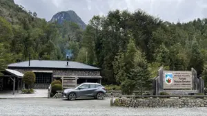
Puyuhuapi – Famous for its hot springs and proximity to the Queulat National Park (Hanging Glacier).
Puerto Cisnes (optional, detour) – Coastal town with access to the sea.
Coyhaique – Regional capital, large city with services and base for excursions.
Southern Austral Highway
Villa Cerro Castillo – At the foot of the hill of the same name, a popular trekking destination.
Puerto Río Tranquilo – From here you can access the Marble Chapels on General Carrera Lake.
Bahía Murta – Small town on the lake shore, less touristy.
Puerto Bertrand – Beginning of the mighty Baker River.
Cochrane – Major city in southern Aysén. Access to Patagonia Park.
Caleta Tortel – Famous for its wooden walkways over the fjords; a town without traditional streets.
Villa O’Higgins – End of the Carretera Austral. From here, there's no direct vehicular access to Argentina, but there are trekking and boating routes.
Puerto Yungay y Puerto Natales , A route that can only be completed by ferry, almost 42 dreamy hours amidst majestic landscapes, where you can observe numerous fauna such as birds and marine species in a habitat full of magic, tranquility and solitude. Below we leave some links for reservations for this section.
RELEVANT DATA
Estimated total length of the Carretera Austral: ~1.240 km
Approximate percentage of gravel: 70%, that is, about 868 km
Remaining paved section: 70%, that is, about 868 km
FUEL REFILLING POINTS
On the Carretera Austral (Route 7), there aren't fuel stations in every town, so it's important to plan your journey carefully. Here's a list, from north to south, of the main towns where you can find official gas stations. (Copec, Petrobras, Terpel) and community charging points:
Puerto Montt – Several service stations (start of the route).
Caleta La Arena – Last gas station before the ferry.
Hornopirén – Copec service station.
Chaitén – Copec service station.
Santa Lucía – Fuel sales point.
Futaleufú (detour from Villa Santa Lucía) – Service station.
La Junta – Copec service station.
Puyuhuapi – Fuel sales in cans (informal, inquire beforehand).
Puerto Cisnes – Service station (detour from La Junta).
Villa Amengual – Basic station.
Villa Mañihuales – Copec service station.
Coyhaique – Various stations (Copec, Petrobras, Shell).
Balmaceda / Aeropuerto – Copec service station.
Villa Cerro Castillo – Sale in drums (informal).
Puerto Río Tranquilo – Sold in drums (check availability).
Puerto Guadal – Small station / drums.
Chile Chico – Copec service station.
Cochrane – Copec service station.
Caleta Tortel – Sold in drums (very limited).
Villa O’Higgins – Sale in drums (very limited, consult before).
Tips for refueling
Always fill the tank at every available station
In small areas, fuel is often sold in cans at a higher price.
Demand increases in summer, and in winter some stations may not have stock.
OUTSTANDING AND UNMISSABLE NATURAL PLACES
- Capital Nacional del Rafting, Futaleuf’ú.
- Pumalín Douglas Tompkins National Park, here we leave you a link https://www.conaf.cl/parque_nacionales/parque-nacional-pumalin-douglas-tompkins/
- Queulat National Park (Hanging Glacier), here are the links https://www.conaf.cl/parque_nacionales/parque-nacional-queulat/
- Cerro Castillo National Park, links of interest https://www.conaf.cl/parque_nacionales/parque-nacional-cerro-castillo/
- Capillas de Mármol, links de intere https://es.wikipedia.org/wiki/Capilla_de_M%C3%A1rmol
- Glaciar Exploradores.
- Confluence of the Baker and NEF Rivers.
- Patagonia National Park, Chacabuco sector, a must-see! Visit it at this link https://www.rewildingchile.org/proyectos/parque-nacional-patagonia/
- Patagonia National Park, Jeinimeni Reserve sector.
- Patagonia National Park, Tamango Reserve sector.
- Northern Patagonian Ice Field (access from Villa O’Higgins) link of interest https://es.wikipedia.org/wiki/Campo_de_hielo_patag%C3%B3nico_norte
- Torres del Paine National Park, links of interest https://www.conaf.cl/parque_nacionales/parque-nacional-torres-del-paine/.
- Laguna San Rafael can be navigated from Puerto Chacabuco or Valle Exploradores.
- Glaciar Calluqueo.
OUTSTANDING NATURAL PLACES(for ferry reservations on the route)
Puerto Montt – Hornopiren y/o Puerto Yungay – Puerto Natales.
https://www.barcazas.cl/barcazas/hornopiren-caleta-gonzalo/
https://www.tabsa.cl/rutas/pyungay-pnatales
OTHER LINKS OF INTEREST
- Tickets to Torres del Paine National Park: https://www.pasesparques.cl/es/parks/torres-del-paine
- To do the W mountain trails and the Paine Massif Circuit you must make your accommodation reservations in the shelters and campsites that have facilities within the park, without them you will not be able to enter the mountain area, this link will help you https://lastorres.com/
- Some camping in Torres del Paine
https://www.cajalosandes.cl/turismo/hoteles-y-cabanas/rio-serrano-torres-del-paine